Home > Animals > Farm > Donkeys > Related Images
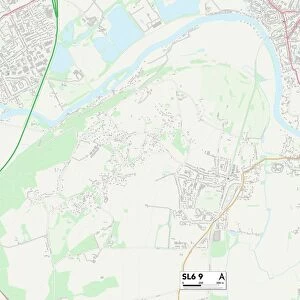
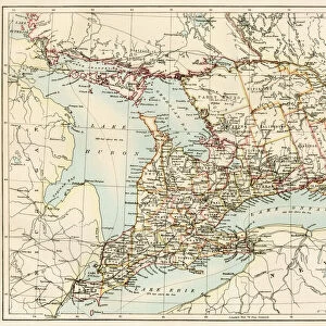
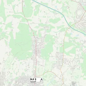
South Buckinghamshire SL8 5 Map

![]()
Wall Art and Photo Gifts from Map Marketing
South Buckinghamshire SL8 5 Map
Postcode Sector Map of South Buckinghamshire SL8 5
Media ID 19978894
Abbey Road Avalon Road Blind Lane Bourne Close Bramley Gardens Brent Road Burnham Close Cherwell Road Church Road Donkey Lane Elm Lane Elms Drive Fairfield Close Farm Road Ferry Lane Furlong Close Furlong Road Greenside Harvest Hill Highfield Road Howard Court Kennet Road Marlow Road Meadow Walk Millside New Road Oakfield Road Princes Road Recreation Road Riversdale Roman Way South Buckinghamshire Spring Gardens Station Road Sycamore Close Thames Close The Avenue The Close The Drive The Parade Walnut Tree Close Walnut Way Wendover Road Wessex Road Wharf Lane Bourne End Camden Place West Ridge
FEATURES IN THESE COLLECTIONS
> Animals
> Farm
> Donkeys
> Related Images
> Animals
> Mammals
> Cricetidae
> Eastern Harvest Mouse
> Arts
> Artists
> B
> Frank Bramley
> Arts
> Artists
> H
> Howard Hawks
> Arts
> Artists
> W
> Frank Weller
> Asia
> Georgia
> Related Images
> Europe
> United Kingdom
> England
> Buckinghamshire
> Burnham
> Europe
> United Kingdom
> England
> Buckinghamshire
> Marlow
> Europe
> United Kingdom
> England
> Buckinghamshire
> Related Images
> Map Marketing
> Postcode Sector Maps
> SL - Slough
MADE IN THE USA
Safe Shipping with 30 Day Money Back Guarantee
FREE PERSONALISATION*
We are proud to offer a range of customisation features including Personalised Captions, Color Filters and Picture Zoom Tools
SECURE PAYMENTS
We happily accept a wide range of payment options so you can pay for the things you need in the way that is most convenient for you
* Options may vary by product and licensing agreement. Zoomed Pictures can be adjusted in the Cart.